Maps and Data
Find maps and charts showing transportation data and trends related to alternative fuels and vehicles.
-
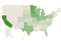
Biodiesel Fueling Station Locations by State
Displays states and their respective biodiesel station counts
-
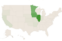
Compressed Natural Gas Fueling Stations by State
Displays states and their respective compressed natural gas (CNG) station counts
-
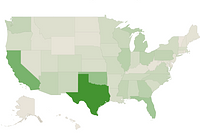
E85 Fueling Station Locations by State
Displays states and their respective E85 station counts
-
Electric Vehicle Charging Ports by State
Displays states and their respective EV charging port counts
-
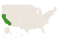
Hydrogen Fueling Station Locations by State
Displays states and their respective hydrogen station counts
-
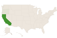
Liquefied Natural Gas Fueling Stations by State
Displays states and their respective liquefied natural gas (LNG) station counts
-
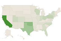
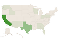
Propane Fueling Station Locations by State
Displays states and their respective propane station counts
-
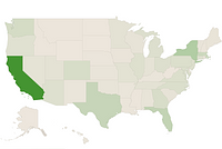
Renewable Diesel Fueling Station Locations by State
Displays states and their respective renewable diesel station counts
-
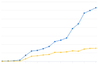
U.S. Private Electric Vehicle Charging Infrastructure
Trend of private electric vehicle charging infrastructure in the United States from 2007 to 2023
Last update March 2024 -
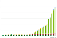
U.S. Public and Private Alternative Fueling Stations by Fuel Type
Trend of alternative fueling station counts by fuel type in the United States from 1992 to 2025
Last update January 2026 -
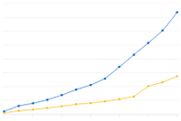
U.S. Public and Private Electric Vehicle Charging Infrastructure
Trend of public and private electric vehicle charging infrastructure in the United States from 2011 to 2023
Last update March 2024 -
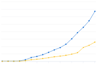
U.S. Public Electric Vehicle Charging Infrastructure
Trend of public electric vehicle charging infrastructure in the United States from 2007 to 2023
Last update March 2024